Home Catalogue SURVEILLANCE SYSTEMS
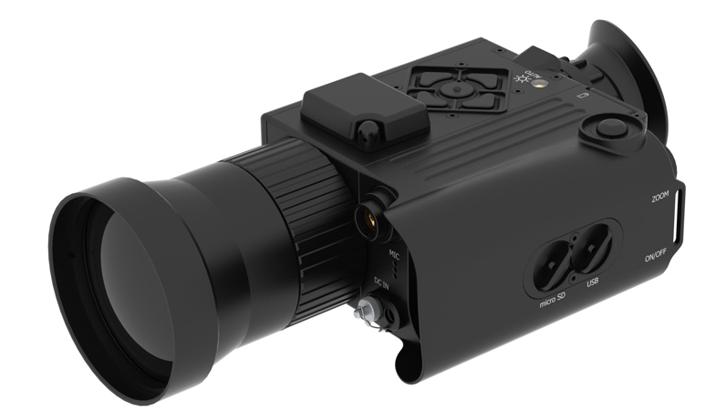
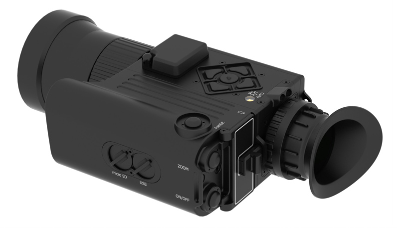
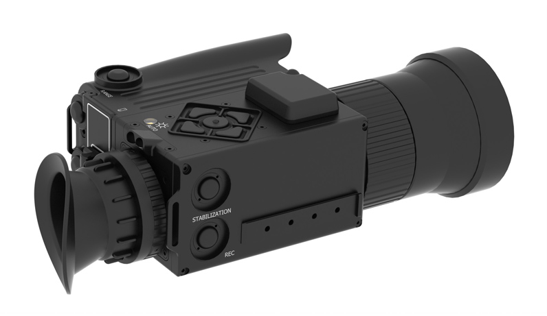
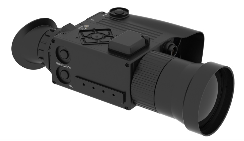
CORSAIR— automated thermal imaging system designed for observation, detection, recognition, identification, terrain orientation, reconnaissance and target designation of unsheltered, camouflaged or partially concealed behind the barrier targets at any time of day and night and invarious weather conditions.
CORSAIR— multitask system, functional and operational capabilities can easily carry out functions of «5» separate devices:
- Thermal-imaging monocular;
- Laser rangefinder;
- Ballistic calculator;
- Meteorological station;
- Navigation device;
CORSAIR– is a modern hi-tech element base of the electronic unit and advanced functional capabilities in one compact device. Thermal imaging sensor, laser rangefinder, meteorological station, Linux OS based computer, ballistic calculator, GPS module, 3-axis gyro sensor, G meter, electronic compass, interfaces of remote control, communications and data transfer are integrated into minimal size and weight shockproof and waterproof aluminum-magnesium alloy case.
Easy handling, universality and multitasking, accordance with the strictest standards – all of that makes CORSAIR at the forefront among existing devices with similar functions.
| Optical system | |
| Lens | 60 mm f/1.0 |
| Zoom | x3, х6, х12, х24 |
| Field of view, 0 | 10,4 х 7,8 |
| Field of view, m for 100 m / yd for 109 yd | 18,1 х 13,6 /19,68 х 14,22 |
| Focusing | Manual, auto (option) |
| Human detection range, m/yd | 1750 / 1914 |
| Human recognition range, m/yd | 450 / 492 |
| Human identification range, m/yd | 225 / 246 |
| Thermal sensor | |
| Type | uncooled microbolometer |
| Resolution | 640×480 |
| Pixel size | 17 µm |
| Spectral range | 7.5 – 13.5 µm |
| Frame rate PAL/NTSC, Hz | 8.3/7.5; 25/30; 50/60 |
| NEdT, F1.0 | < 50 mК |
| Monochrome and colour palletes | Yes, 12 modes |
| Sensor calibration | Yes, internal shutter (auto or manually) |
| LRF | |
| Laser wavelength, nm | 905 / 1550 (option) |
| Distance measurement range, m/yd | 6 – 2500 / 6 – 2734 |
| Range measurement accuracy | 1 m |
| Calculation of the true distance to the target (taking into account elevation adjustment) | + |
| LRF reticle alignment on the device display | + |
| Display | |
| Type | OLED |
| Resolution | 800х600 |
| Eye relief | 30 mm |
| Diopter adjustment | ±3 diopters |
| Interfaces | |
| USB | microUSB |
| Wi-Fi | 802.11 b/g/n |
| Bluetooth | + |
| Radio interface, 2.4 GHz | + |
| Additional functions | |
| Memory card microSD | up to 32 Gb |
| Audio, video, photo recording | + |
| Data reading of a microSD or internal memory via USB | + |
| Firmware upgrade via USB, microSD | + |
| Streaming video transmission via Wi-Fi | + |
| Setting and control via Wi-Fi | + |
| Connection of additional devices (remote, wind station, etc.) via a radio channel | + |
| Profile settings | + |
| Setting via IR&D software | + |
| Quick menu | + |
| Buit-in navigation and mapping | + |
| Self location and target location on the integrated map | + |
| Picture in picture mode | + |
| Target size measurement | + |
| Video recording modes | Per motion detection, manually |
| Power saving modes | + |
| Integrated motion detector | + |
| Automatic display brightness correction | + |
| Digital image gyrostabilization | + |
| System settings | |
| Switch-on time | <15 seconds |
| Battery life | >4 hours (at 0°С) |
| Battery type | 2 х 18650 |
| Input for an external power supply | + |
| Range of the external power supply voltage, V | 10 – 24 |
| Integrated sensors list |
|
| Rest sensor | + |
| Eye sensor | + |
| Free Fall sensor | + |
| Light sensor | + |
| Elevation sensor | + |
| Roll angle sensor | + |
| Temperature sensor | + |
| Pressure sensor | + |
| Humidity sensor | + |
| Switch-off timer | + |
| GPS module | + |
| Digital compass | + |
| Gyroscope | + |
| Physical parameters | |
| Operating temperature range | -40°С… +65° С |
| Ingress protection rating (Waterproof) | IP66 |
| Housing material | Aluminum-magnesium alloy |
| Dimensions, mm | 205 x 112 x 71 |
| Weight (without batteries), g | 492 |

Features
- IR&D high-selective rangefinder operation modes: fog, dust-storm and in other adverse weather conditions at distances range from 5 to 2500 meters;
- Target range designation through translucent barrier (bushes, meshy fence);
- Built-in meteorological station (atmospheric pressure, air temperature and humidity);
- Built-in sensors: rest, tilt and elevation angle, free fall, eye, illuminance, 3-axis gyro sensor and G meter;
- Built-in GPS module and electronic compass;
- Automatic calculation of several targets coordinates and distance between them (by the range, elevation angle, azimuth and device’s coordinates);
- Navigation service with routing to position of hitting a target;
- Image stabilization in observation mode (hand tremor, moving transport);
- PIP (picture in picture) provides comfort observation at any zoom and at the same time to control all the field of view at the panoramic view screen;
- Motion detection – when motion of a thermal contrast target is detected, shooter is notified by the indication on the screen and vibration of remote control (wristband) (security alert);
- Autofocus mode – provide automatically focus at the object by measured or manually set distance (optional);
- Automatic and semi-automatic target size measurement mode – provide an opportunity to measure target size (accurate to centimeter) on arbitrary distances in any zoom;
- Automatic calculation of vertical and horizontal amendments at the distances up to 1500 meters considering:
- Target range;
- Elevation angle;
- Atmospheric pressure, air temperature and humidity;
- Wind direction and strength;
- Ballistic characteristic of bullet, derivation and Coriolis effect;
- Ballistic data base for three ammunitions for each of eight rifles;
- Front Focus software modeling –reticle scales synchronously with target at zoom changing, which provides by using of the MIL/MOA creticle:
- determine distance to the target knowing target’s angular dimensions (without using of the rangefinder);
- determine target dimension at known distance;
- Profiles – joins and saves numerous of personal settings. User can quickly select most suitable profile to the firing conditions (time of day, weather, landscape);
- Connection of the wireless accessories via telemetric radio channel:
- remote control (wristband) (optional);
- meteorological station measuring wind speed and direction, atmospheric pressure, air temperature and humidity sensors (optional);
- External power unit (optional);
- Built-in IR illuminator (illumination and target designation for night vision devices);
- Rangefinder hunting detector (optional);
- Target designator (optional);
- «Friend-or-foe» system (optional);
- Bluetooth headset for voice guidance about operating modes and calculation results (optional);
- Regular attaching point for special brackets or tripod;
- Database backup to microSD memory card;
- Photo and video recording (with sound) with telemetric information overlaying; (supports microSD memory card up to 32 GB);
- Automatic video recording by event «detection by motion detector» with synchronous alert to the remote control by vibration;
- Matching of a recorded photo and video to the digital terrain map (geotagging);
- Video streaming with capability of the device operation by using of Wi-Fi of iOS, Android devices;
- Special communication interfaces – integrate the device with other IR&D sighting systems;
- Adjustment and device control by using of Windows, Linux, OS X, Android based devices;
- Ability of independent software update from the manufacturer site (developing of new functions and software);
- Ability to finish writing and creation of a new functionality by technical specifications of the customer;
- English, German, French and Spanish interface. Ability of any language support by the customer’s request is provided (optional);
- Online service, advisory support and training, twenty-four-hour support for the customers
CREATE AN ACCOUNT